Some of the best village ramparts in France
Tuesday 28th March
We set off from Forres at 14:20 for Inverness. Tonight we have tickets for the Yamato Drums at the Eden Court Theatre and have decided to stay over in Bertie and then have a few days exploring northwards up the Caithness coast. We drove straight to Invermess, with a quick victualling stop at Lidl in Forres en-route, and filled up with diesel at Morrisons on the way into Inverness. We drove through the middle of Inverness to our planned overnight spot at Bught Road in Inverness – as recommended on WildCamping website. However on arrival there were a number of No Overnight Parking signs and no other motorhomes in sight so we decided this was not for us. We drove back around the narrow residential street and parked up outside the Eden Court Theatre so that we could collect our tickets from the box office and we could also suss out the big car park behind the theatre which is free after 6pm. This too has no overnight camping signs so we could not stay here but we could park here until after the performance. I had a backup parking location in mind that I thought we could use as long as we turned up late!
The performance by Yamato Drummers official website was amazing – three hours of pure energy and inspired drumming. Words fail me but I would see them again if I had the chance.
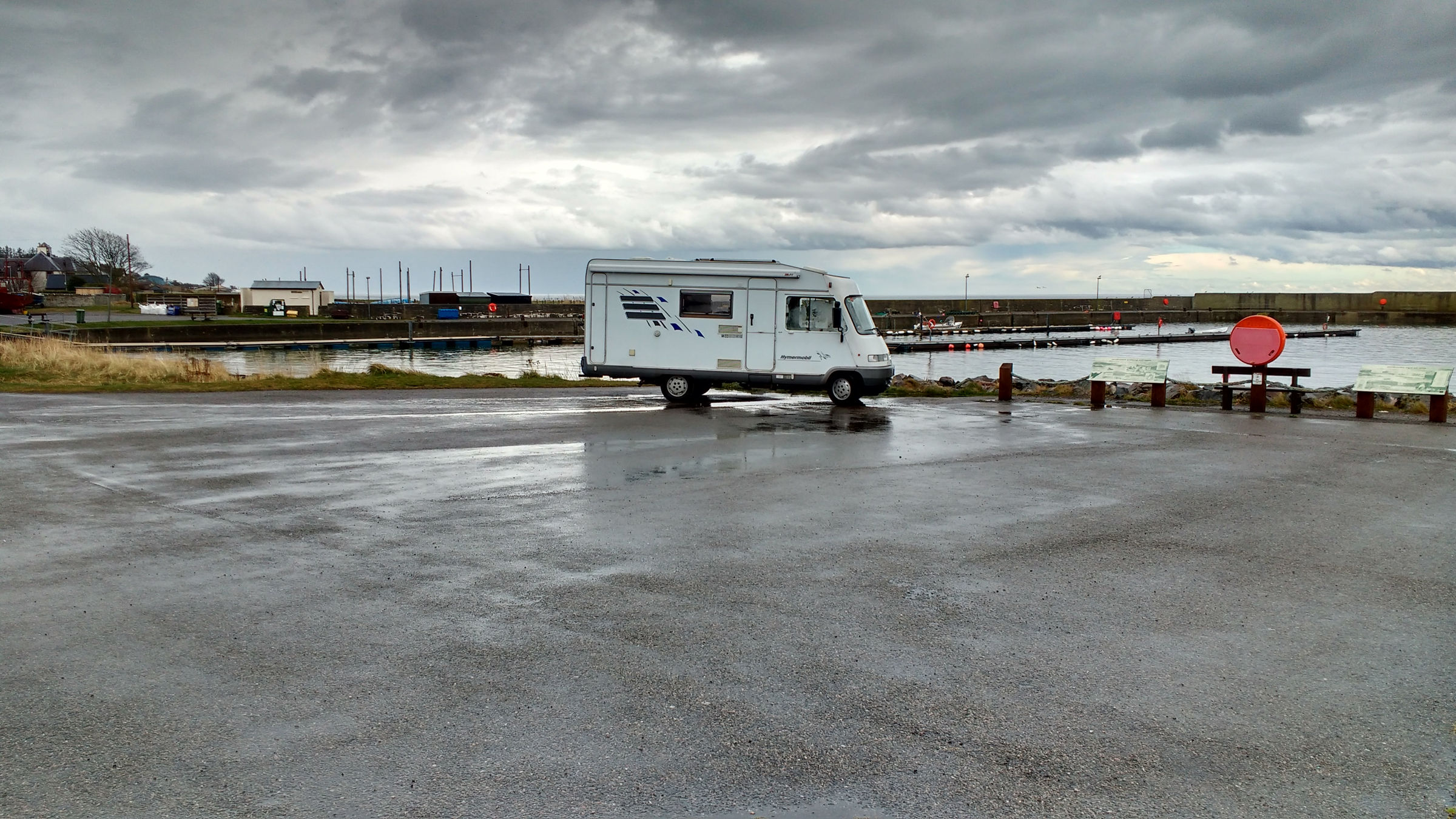
We returned to Bertie in the car park about 10:00pm and we drove out to the little car park at Markinch by the terminal for the old ferry that use to link Inverness to The Black Isle. That ferry has been replaced by the Kessock Bridge but the slipway and car park remains on the far north east edge of Inverness. There is a round turning point for vehicles at the end of the road and all around that is a car park for the Markinch Nature Reserve to the west. The views are stunning as you are on the end of a peninsular jutting out between Beauly Firth and Moray Firth. We parked up here and checked that we were not obstructing the buses that might want to turn and checking the timetable at the bus stop we were surprised to find that several buses would be turning here this evening!

We put Bertie’s windywarmer on and settled down for a peaceful night. I do not even remember hearing to 11:55pm bus turning round.
Wednesday 29th March
After a quiet night, once the buses stopped, we woke to a grey, misty morning that was actually quite chilly but over breakfast the mist cleared and the sun came out for a while. We were not in a hurry and had a lazy start leaving the car park at 11:15 to cross the Kessock Bridge and start the run north.

We decided to slip off the A9 just after the Kessock Bridge to explore a couple of possible future wild camping spots in North Kessock but found the perfect one directly across from our spot last night at the other end of the old ferry now has No Overnight Parking signs but there was a spot beside the RNLI station underneath the Kessock Bridge which might be possible. After coffee at the North Ferry Terminal we returned to A9 driving across the southern end of The Black Isle.

After a few scenic detours around Beauly and Dingwall we rejoined the A9 very briefly before swinging left on The Struie Road across the hills behind Alness toward Bonar Bridge. We had hopes of finding a scenic spot for lunch but had to make do with a roadside pull in. We had also hoped for a good wifi signal but the mifi unit has struggled since we left Inverness. Maybe if we go nearer the coast it will get better.

We pulled over at the Struie viewpoint above the Dornoch Firth to look at the view – there was not one really as the cloud was low and the light was poor. Still no mifi so we pressed on through Bonar Bridge pinning our hopes on Dornoch town. Sadly we arrived in Dornoch just a few minutes after the Tourist Information office closed so could not ask them about net access. Still no signal on the mifi – even in the middle of Dornoch. Ever hopeful we pressed on to our planned stopover at The Mound which was a glorious spot (albeit cold, wet and windy!!) and well worth remembering for the next time we come this way as the views are wonderful and there some possible walks from here too and lots of birds to watch.


We will have to get this internet access issue sorted tomorrow – but with no internet I could not even look up where the coverage was better!
Thursday 30th March
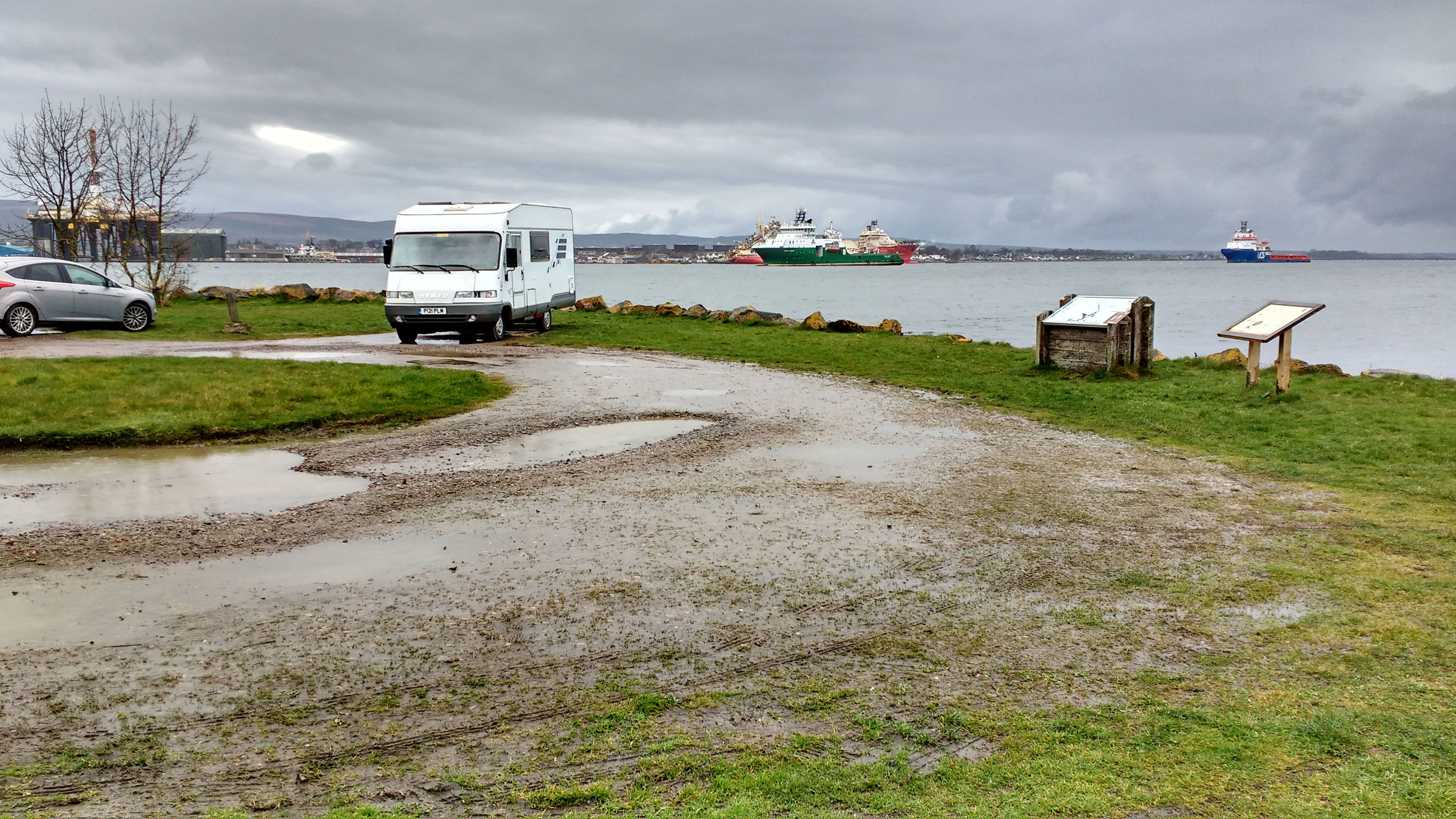
Today we have to get decent internet access as we have bank business that must be done before the end of the month. After much debate we decided to turn back and abandon our journey north – we can do that another time when the weather is better but we can’t miss the banking deadline. Just before 10am we pulled back on to the A9 but this time facing south. We pulled over once or twice to check the mifi signal on the router but we almost back to Alness before we got a three bars! We had pulled in to a layby on the A9 and it was neither scenic or peaceful (far from it actually) but we could get everything done that needed doing with a good 4G signal. Now I could check the EE network coverage to find that there is virtually none north of Tain – I should have checked this before we left.
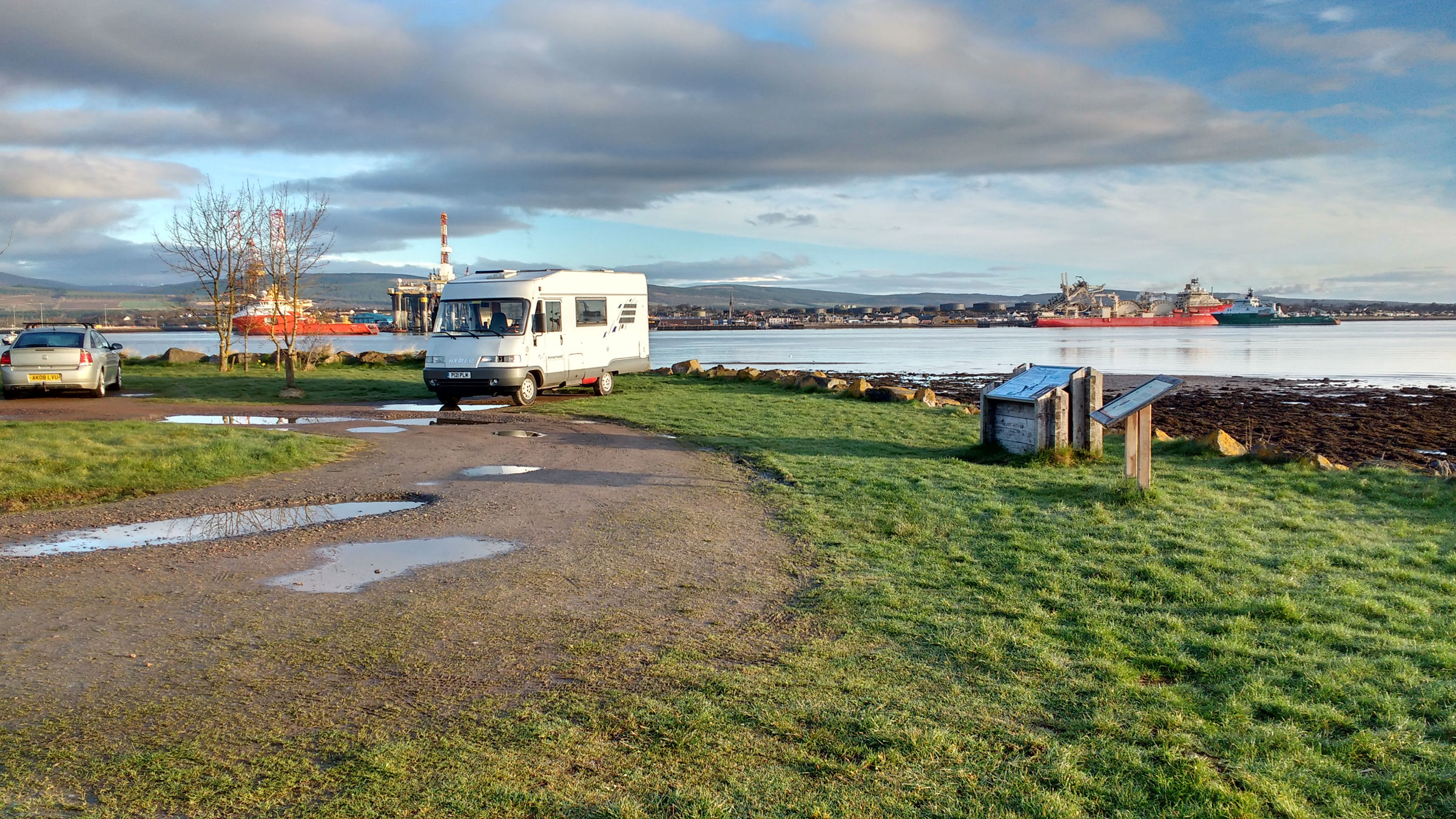
Once the business was done we drove down to the shore of the Cromarty Firth and found a lovely spot to have lunch in a quiet layby in Saltburn on the quiet road beside the Firth from Invergordon to Kildary.

We sat in Bertie with the big window looking out on to the Cromarty Firth enjoying the views across the firth to the village of Cromarty and the Cromarty Gap – the opening in the hills that links the Cromarrty Firth with the open sea of the Moray Firth beyond. It was a lovely spot and we did wonder about spending the night here but as were just opposite a row of houses we decided we wanted some where a bit more remote.
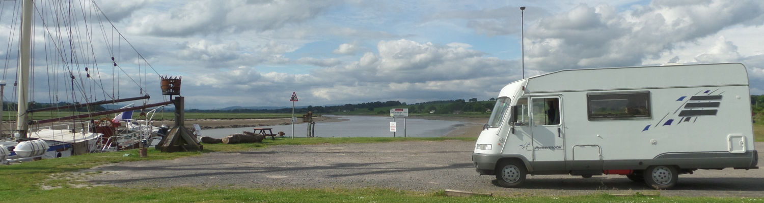
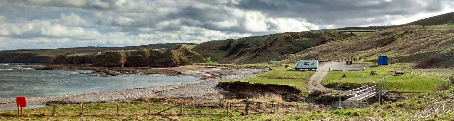
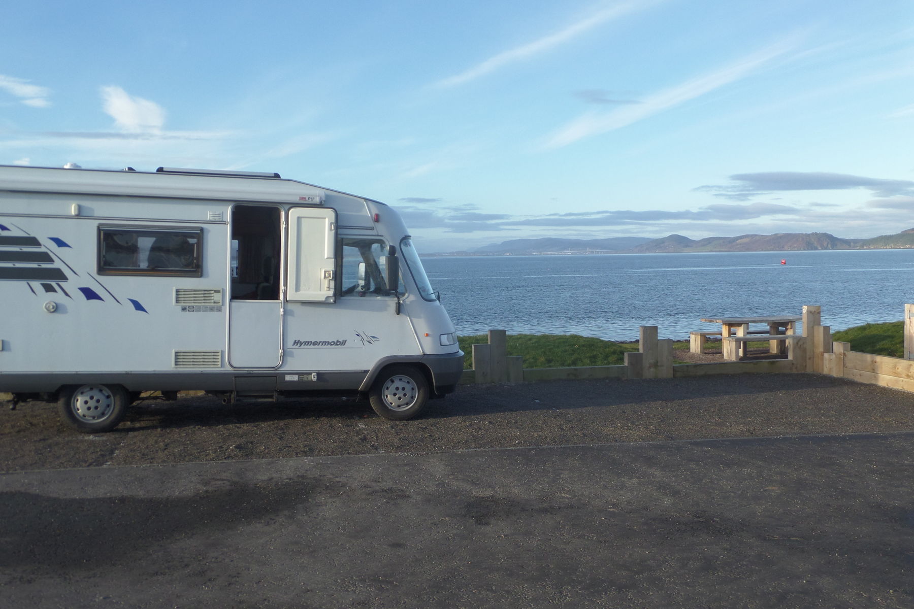
We found that remote spot at Tarbetness which is the point at the very end of the Great Glen. The Black Isle ends at the Cromarty Gap but just across the gap is the Fearn Peninsula. It is a fascinating and little visited area with all the charm of the Black Isle and a rich Pictish heritage. Anyway this chunk of land runs from the Cromarty Gap to Tarbart Ness which latter marks the point where the Dornoch Firth joins the Moray Firth. Apart from being a very scenic location with terrific views all around it is also almost directly opposite Findhorn and this lighthouse is the one we can see flashing when we are on the beach at Findhorn to see the sunset.
We parked in the lighthouse car park facing the sea and looking back toward Forres and Findhorn.


There are no services here and the access road is single track for several miles from Portmahomack and has quite a sharp turn at one point – not advised for anything longer than 7m but well worth the effort of getting here. We walked up to the end of the Ness and enjoyed the views and the birds and the rockpools. What a spot and completely free!!
After dinner once it was fully dark we sat in the front of Bertie and tried to puzzle out all the lights we could see across the Firth – we think we worked out Kinloss base and RAF Lossiemouth, Burghead and even thought we could make out the lights of Forres. It felt strange to be sitting there as the lighthouse flashed beside us looking back at the view we know so well from the other side!
Friday 31st March
We left Tarbart Ness Lighthouse at noon. We had a a bit of lie in having sat up in that dark last night trying to work out the pattern of ligts across the Firth! After a late breakfast we caught up with the some emails and I carefully emptied the grey water tank in to the bucket and thence into the bushes. The weather was not good and seemed to be deteriorating with low clouds and showers as we headed down the east coast of the Fearn Peninsula. Our target first was the little fishing villages of Balintore and Shandwick as we had not explored these before and I was interested to check a possible wild camping location at the Balintore Harbour.
Driving along the shore road in Balintore we were intrigued to see a brown tourist sign pointing east (ie seaward on the shore road!) to the Mermaid of the North. We swung left and parked and went to investigate.
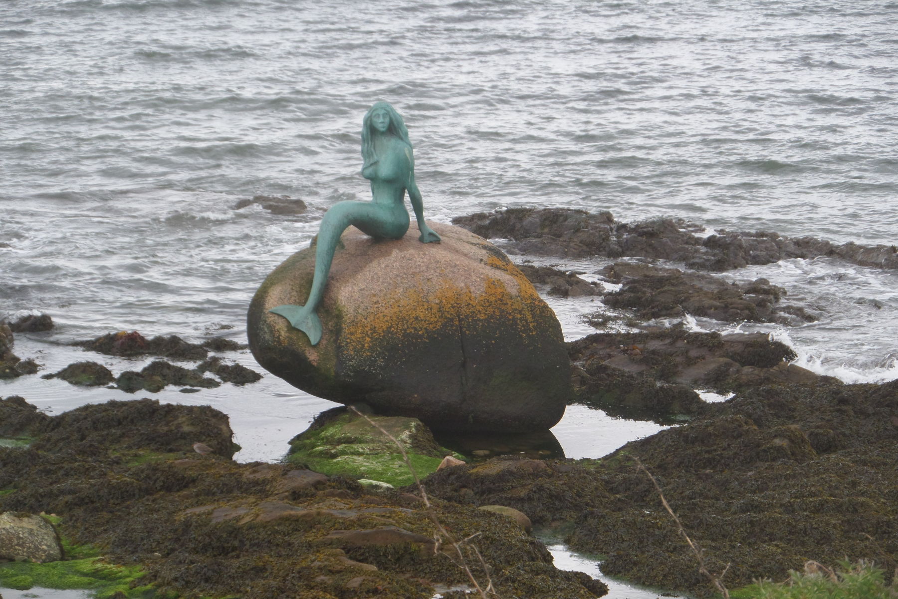
We soon found the mermain – a sculpture on a rock exposed at low tide but swept by the waves at high tide. It turns out that this was created by a local scupltor in 2007 as part of the Highland Year of Culture. It is beautifully done and perfectly located albeit so far away from most people that I am not sure she gets as many visitors as she deserves. You can read a bit more about hert on the local website
From the Mermaid we drove to the harbour at Balintore which offered a fine car park near the pub and toilet block and a water tap. We stopped here for a very late lunch and watch the plovers, redwings, oyster catchers and others we did not know on the breakwater. It was grey, wet and windy but still the view was good and we love this coast. After lunch the rain eased and we took the opportunity to top check out the loo block (closed) and found an outside tap that worked and so we filled up with fresh water so that we could have showers tonight. This would make an excellent free stopover and given better waether I could spend a day or so here walking the coast and enjoying the views.
After Balintore we followed tehcoast road through Shandwick and then turned inland around the top of the Cromarty Firth and then picked up the road along the west shore of the firth through Barbaraville (her sister is imortalised in the even smaller village of Jemimaville on the opposite shore of the firth near Cromarty) and Invergordon. The Cromarty Firth is an important deep sea port for the oild industry and now for the offshore wind business and most of this is concentrated in Invergordon where oil rigs are serviced and repaired. The firth usually shelters a number of rigs that not being used and rig supply tugs are often here too. This is also where the cruise ships dock for Inverness – I wonder what all these tourists think who are coming to see the Scottish Highlands, Loch Ness and Inverness to be greated with this industrial sprawl. That said Inverness is far from pretty although it has a few cute corners if you get a sunny day and are careful how you point the camera! It has much in common with Gorleston or Lowestoft in that way.
We crossed the southern end of the Firth on the A9 bridge which is quite unlike its near neighbour, the mighty Kessock Bridge, as this one is low and flat and close to the water. Just across the bridge we turn off left and start back northwards following the west coast of the Black Isle. Our desitantion for tonight was the car park at Newhall Point on the edge of Udale Bay which is an RSPB reserve on the eastern side of the Cromarty Firth. It looked a perfect spot with superb views west and north with some great birdwatching to be had. It delivered all that and more but we had not realised how close it was to Invergordon just across the firth and nor that there would be several largeish rig support ships moored just off Invergordon (ie even closer to us). These ships keep their engines running 24×7 to power their systems and there was a constant engine rumble in background which became even more noticeable at night!
Saturday 1st April
We wook early after a night that was not improved by the noise from the ships! In fact we decided that we would move before breakfast! The saving grace was that the clouds had broken and the sun was back.
We drove across the Black Isle to Rosemarkie and then down to the end of Chanonry Point – reputedly the best place in Scotland to see the bottle nosed dolphins that the Moray Firth is famous for. We have been here several times but, like today, did not see any of them! Chanonry Point sticks out in to the Firth almost opposite another point of land at Ardersier with Fort George at its tip and btween them these points pinch the flow of water in and out of the inner Moray Firth and the Beauly Firth beyond and this concentrated the salmon and that attracts the dolphins. I suspect we need to choose our times more carefully both with regard to season and especially with regard to the tide state. Anyway we had the car park almost to ourselves with just one other motorhome who had been their wll night (we had a chat to them of course). We had breakfast with a super view along the firth back toward Inverness and the Kessock bridge – actually the exact reverse of the view we had on Wednesday when we were at Inverness looking north along the Firth under the Kessock Bridge.
After breakfast we had a walk along the beach around the point looking for these elusive cetaceans again with out luck! Although time to run for home we had one last treat in store – Beauty and Beast at the Vue cinema at Inverness and second rate lunch at Pizza Hut! We got back to Forres at 5:30pm
Cromarty Firth and the Black Isle